
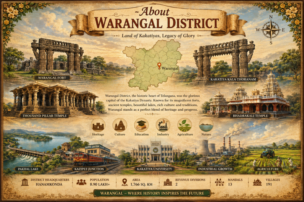
Warangal District Overview
Warangal District is one of the most historically significant districts in Telangana, India. Renowned as the former capital of the Kakatiya Dynasty, Warangal is celebrated for its rich cultural heritage, magnificent temples, ancient forts, and architectural marvels. The district serves as an important center for education, agriculture, tourism, and economic development in the state.Located in northeastern Telangana, Warangal District is known for its blend of historical grandeur and modern progress. The district is home to iconic landmarks such as the Warangal Fort, Thousand Pillar Temple, Bhadrakali Temple, and the famous Kakatiya Kala Thoranam, which symbolizes Telangana’s glorious past.
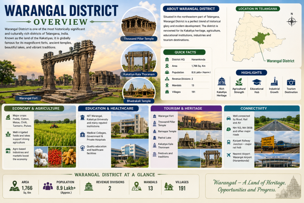
Administrative Divisions

2
Revenue Divisions

13
Mandals

191
Villages
Sample Villages by Mandal
| Mandal | Example Villages |
|---|---|
| Chennaraopet | Akkalcheda, Ameenabad, Gurijala, Konapuram, Lingagiri, Papaiahpeta, Suripalle |
| Duggondi | Adavi Rangapur, Chalparthi, Keshwapur, Mallampalle, Ponakal, Rekampalle, Venkatapur |
| Geesugonda | Anantharam, Dharmaram, Elkurthy, Gorrekunta, Mogilicherla, Shayampet, Vasanthapur |
| Khanapur | Ainepalle, Appalaraopet, Bollikonda, Chandrugonda, Mudigonda, Nagaram, Venkatapur |
| Parvathagiri | Annaram Sharif, Burugamadla, Choutapalle, Kalleda, Konkapaka, Ravoor, Somaram |
| Raiparthy | Burahanpalle, Gannaram, Jagannadhapalle, Muripirala, Mylaram, Raiparthy, Sannur |
| Sangem | Bollikunta, Gavicherla, Lohitha, Mondrai, Mummadivaram, Ramachandrapur, Venkatapur |
| Warangal | Desaipet, Enumamula, Girmajipet, Kothapet, Mattewada, Paidipalle, Ramannapet |
| Wardhannapet | Bandauthapur, Chennaram, Dammannapet, Inole, Panthini, Ramavaram, Yellanda |
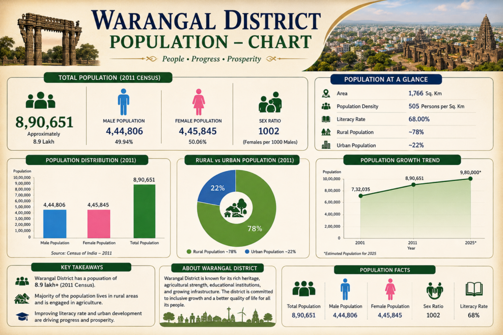
About the Population of Warangal District
Warangal District is one of the prominent districts in the state of Telangana, known for its rich cultural heritage and steadily growing population. The district is home to a diverse community living across urban centers, towns, and rural villages. Agriculture, education, trade, and service industries play a significant role in supporting the livelihoods of its residents.
With continuous improvements in infrastructure, healthcare, education, and public services, Warangal District has witnessed steady socio-economic development.
Male Population
4,44,806
Female Population
4,45,845
Sex Ratio
1002 (Females per 1000 Males)
Warangal District – Statistics at a Glance
General Information
- State: Telangana
- District Headquarters: Hanamkonda
- District Name Origin: Orugallu (One Stone City)
- Formation: Reorganized on 11 October 2016
Area & Geography
- Total Area: 1,766 Sq. Km
- Elevation: Approx. 288 meters above sea level
- Major Water Bodies: Pakhal Lake, Dharmasagar Lake
- Climate: Tropical Semi-Arid
Population Statistics
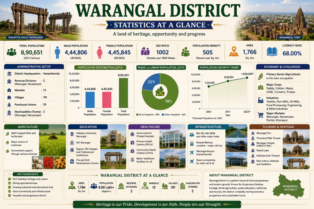
- Total Population: 8,90,651
- Male Population: 4,44,806
- Female Population: 4,45,845
- Sex Ratio: 1002 Females per 1000 Males
- Population Density: 505 Persons/Sq. Km
- Literacy Rate: 68%
Administrative Statistics
- Revenue Divisions: 2
- Warangal
- Narsampet
- Mandals: 13
- Villages: 191
- Gram Panchayats: 323
Major Crops
- Paddy
- Cotton
- Maize
- Chilli
- Turmeric
- Pulses
Major Industries
- Kakatiya Mega Textile Park
- Rice Mills
- Cotton Ginning Units
- Food Processing Industries
- Engineering Industries
Education Statistics
- Major Universities: 2
- Kakatiya University
- NIT Warangal
- Government & Private Degree Colleges
- Engineering Colleges
- Polytechnic Institutions
- Skill Development Centers
Healthcare Statistics
- Government Hospitals
- Community Health Centres (CHCs)
- Primary Health Centres (PHCs)
- Private Multi-Speciality Hospitals
- Rural Healthcare Network
Previous History of Warangal District
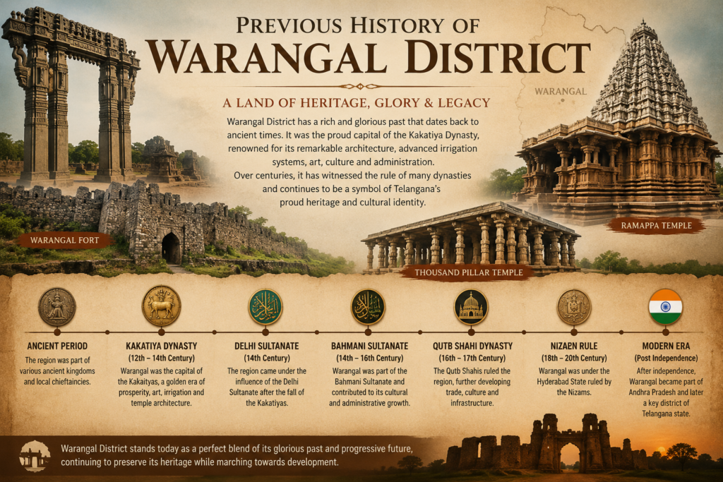
Warangal District is one of the oldest and most historically significant regions in Telangana, renowned for its rich cultural heritage and architectural grandeur. It served as the capital of the Kakatiya Dynasty from the 12th to the 14th century, a period marked by remarkable advancements in administration, irrigation, trade, art, and temple architecture. Iconic landmarks such as the Warangal Fort, Thousand Pillar Temple, and Ramappa Temple stand as enduring symbols of the district’s glorious past.
Over the centuries, Warangal came under the rule of the Delhi Sultanate, Bahmani Sultanate, Qutb Shahi Dynasty, and later the Hyderabad State under the Nizams. Following India’s independence, Warangal became part of Andhra Pradesh and, after the formation of Telangana in 2014, emerged as one of the state’s most important cultural, educational, and economic centers. Today, the district continues to preserve its historical legacy while embracing modern development in infrastructure, education, tourism, and industry.
| Year/Period | Event |
|---|---|
| Ancient Era | Early settlements in the region |
| 1199 AD | Warangal became Kakatiya capital |
| 1262–1289 AD | Reign of Rani Rudrama Devi |
| 1323 AD | Fall of Kakatiya Kingdom |
| 14th–16th Century | Bahmani Rule |
| 16th–17th Century | Qutb Shahi Rule |
| 1724–1948 | Nizam Rule |
| 1948 | Hyderabad State integrated into India |
| 1956 | Became part of Andhra Pradesh |
| 2014 | Telangana State Formation |
| 2016 | District Reorganization |
Measurement of Warangal District
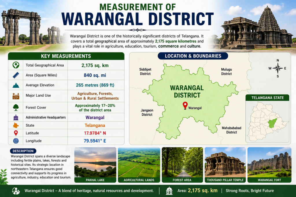
Warangal District is one of the historically significant districts of Telangana, known for its cultural heritage, agricultural lands, and growing urban development. The district covers a geographical area of approximately 2,175 square kilometres (840 square miles), making it an important administrative and economic region in the state.
The district is characterized by fertile plains, small hillocks, forests, lakes, and irrigation tanks that support agriculture and biodiversity. Warangal District shares its boundaries with Hanumakonda, Mulugu, Mahabubabad, Jangaon, and Siddipet districts, providing strong connectivity and regional importance.
| Category | Measurement |
|---|---|
| 📍 Total Geographical Area | 2,175 sq. km |
| 📐 Area (Square Miles) | 840 sq. mi |
| 🏞️ Average Elevation | 265 metres (869 ft) above sea level |
| 🌾 Major Land Use | Agriculture, Forests, Urban & Rural Settlements |
| 🌳 Forest Cover | Approximately 17–20% of the district area |
| 🗺️ Administrative Headquarters | Warangal |
| 🌍 State | Telangana |
| 📍 Latitude | 17.9784° N |
| 📍 Longitude | 79.5941° E |
Revenue Administration of Warangal District
The Revenue Administration Department plays a crucial role in the governance and development of Warangal District. It is responsible for land administration, revenue collection, maintenance of land records, implementation of welfare schemes, disaster management, and public service delivery.
Warangal District is divided into 2 Revenue Divisions and 13 Mandals, ensuring efficient administration and governance at the grassroots level.
| Category | Details |
|---|---|
| Revenue Divisions | 2 |
| Mandals | 13 |
| Villages | 191 |
| Gram Panchayats | 323 |
| District Headquarters | Hanamkonda |
🌤️ Warangal District Weather Report
Live Weather Updates
Warangal District Showcase
Historic Heritage • Tourism • Agriculture • Culture
Warangal
| Category | Historic City |
| Known For | Kakatiya Heritage |
| Economy | Tourism, Education, Trade |
| Tourist Places | Warangal Fort, Bhadrakali Temple |
| Special Feature | Cultural Capital of Telangana |
Hanamkonda
| Category | Educational Hub |
| Known For | Thousand Pillar Temple |
| Economy | Education & Commerce |
| Tourist Places | Thousand Pillar Temple |
| Special Feature | Major Urban Centre |
Kazipet
| Category | Railway Junction |
| Known For | Railway Connectivity |
| Economy | Transport & Trade |
| Tourist Places | Local Attractions |
| Special Feature | Major Transport Hub |
Narsampet
| Category | Agricultural Town |
| Known For | Paddy & Cotton Markets |
| Economy | Agriculture & Trade |
| Tourist Places | Pakhal Lake Nearby |
| Special Feature | Regional Market Centre |
Parkal
| Category | Historic Town |
| Known For | Parkal Memorial |
| Economy | Agriculture & Business |
| Tourist Places | Historical Sites |
| Special Feature | Freedom Movement History |